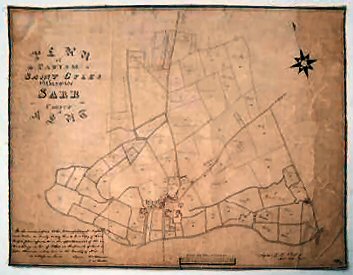
Plan Of The Parish Of St. Gyles Otherwise Sarr In The County Of Kent..
Some surface dirt and slight discolouring, later pencilling of names, with occasional additions in pencil.
£750.00
Details
MANUSCRIPT TITHE MAP
Publisher
Surveyor's signature abraded and so far not traced. [John ???man].,
Date
1843
Synopsis
We the undersigned tithe commissioners for england and wales do hereby certify this to be a copy of the map and plan referred to in the apportionment of the kent charge in lieu of tithes in the parish of st. gyles otherwise called sarr in the county of kent. as witness our hands signed william blamire and t w buller.
signed g h whalley, assistant tithe commissioner. [signed with initials] e.j.w. 23/3/43
Item Description
Finely drawn manuscript tithe map, 25 x 18.75 ins. Ink and colour wash on paper, mounted and laid on linen.
Notes
A very attractive mid-19th century Kentish tithe map of the parish now known as Sarre. An interesting feature of the map is that it shows an intricate network of water-filled ditches fed by the River Stour, which were presumably water-meadows. The scale is given at 6 chains to the inch. The fields are numbered and the owners' names have been pencilled on to the map in a later hand. We have obtained a copy of the tithe schedule dated 1841, and most of the information on ownership is the same. From this list we know the uses of each field, i.e. its cultivation (marsh, arable, pasture etc). It also identifies all the buildings on the map, with ownership and use. Using Google Earth, it can be seen that the modern field patterns remain remarkably consistent, the most obvious change being the arc of the railway which cuts across the lower right hand quadrant of the map and the addition of new housing developments. The windmilll still stands (in working order), with the nearby turnpike cottage still standing on the Ramsgate-Canterbury A253. It is truly remarkable that so little has changed in the more than 170 years that have passed since the map was made.
The Tithe Commutation Act of 1836 set up the Tithe Commission headed by three Commissioners sitting in London, William Blamire (1790-1862), Captain Thomas Wentworth Buller, RN, (1792-1852) and the Rev. Richard Jones. By 1841 G.H. Whalley was an Assistant Commissioner. The Act allowed the substitution of a money payment - the tithe rent-charge - for payment in kind. The first tasks of the Commissioners were to find out where commutation had already taken place, and also to establish the boundaries of every unit in which tithes were paid separately. This unit was known as a tithe district to distinguish it from a parish or township. This map would appear to be a result of these enquiries.
[Stock No. 20446]
Subjects
19th Century • Kent • Manuscripts • Maps • Rivers • Roads • Social History • Thanet • Topography • Villages • Waterways