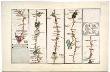
London To Rochester..
Hand coloured road map in six strips extracted from larger work and mounted on card.
£150.00
Details
KENT TURNPIKE ROADS
Publisher
J. Cary.,
Place
[London]
Date
1790
Synopsis
[from cary's survey of the high roads from london, first edition 1790].
Item Description
Road map. 12.5 x 7.5 inches.
Notes
This map illustrates the route from Southwark via New Cross, Deptford, Greenwich, Blackheath, Woolwich, Bexley Heath, Crayford, Dartford, Stone, Northfleet, Gravesend, Chalk Street, Shorne and on to Stroode, Rochester and Chatham. Woods, commons, gentlemen's seats and public houses are shown with a separate table of the inns in towns. As this is a road map for the use of travellers all the turnpike toll gates are indicated with helpful notes as at 'Deptford Gate pass with Green Man Gate ticket' (From the Green Man Gate by the public house of that name). John Cary (1755-1835) was a London cartographer, engraver, globe maker and publisher, considered by many to be one of the finest of his day, known for his high standards and continuous edition improvements. Several later editions of Cary's Survey were published up to 1810.
[Stock No. 22433]
Subjects
18th Century • Kent • Maps • North Kent • Roads